Mobile Data
Define Trade Area by Mobile Data

Background
A grocery store near Eglinton and Yonge in Toronto wanted to understand the geographic concentration and demographic profile of consumers around its store during the day so that they could tailor product offerings and communications more effectively.
Analytic Objectives
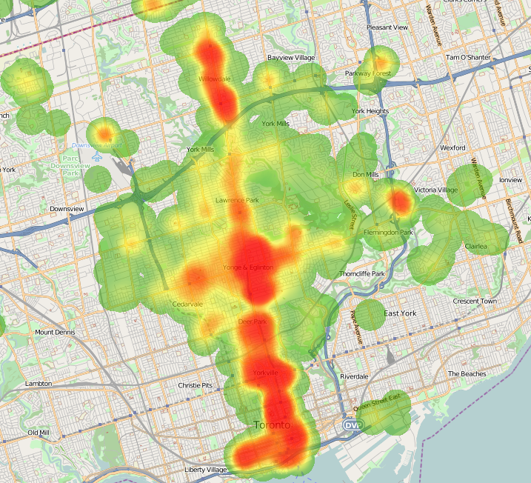
The objective of analytics was to identify and map the store’s trade area and perform consumer profile analysis.
Manifold’s Approach
We set up a geo-fence around the store. Using Streetlight’s mobile GPS data, we extracted all origin Dissemination Areas (DA) in Toronto from which at least one consumer entered a geo-fence around the store during the day. Thereafter, by linking the DAs to 6-digit postal codes and weighting the count of consumers, we were able to:
- Create heat maps of consumers;
- Create consumer demographics, spending, product, and media usage, and lifestyle profiles;
- Compare the “Dynamic” trade area with Toronto as a benchmark to identify gaps and opportunities.
Trade Area Defined by Mobile Data
The following map shows the concentration of consumers who were near the store (in the geo-fence) for some time during the day. Evidently, this is very different from the traditional circular and driving time trade areas.

Demographic Profiles
Compared with Toronto’s average consumers, people who were near the store during the day have more likely the following characteristics.
- Singles or couples without kids;
- 25 to 44 years old with a university degree and very high income;
- Tenants and European ancestry;
- Affluents and Elite Professionals;
- Drive less (lower mileage), but drive premium European/Japanese automobiles;
- Active on social networks: LinkedIn and dating sites.
Benefits
- Consumers who were in the store’s geo-fence have distinct characteristics, purchasing power, and behaviour.
- Insight into the consumers helped the grocery store optimize their inventories and reduce the cost of promotions by targeting the right clientele with the right promotional messaging at the right times.