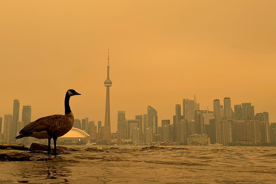
Wildfires arrived in southern Ontario on Tuesday, July 14th in a way few people will forget.
If you looked outside on Wednesday morning, you immediately noticed that something was wrong. Residents all across the GTA woke up to a completely orange sky, and an overwhelming stench. On Wednesday morning, I checked my phone and immediately saw an air quality alert of 8: high-risk air pollution. The map showed bright orange in my area, with a huge cloud of dark red fast approaching. On Thursday, the warning had increased to 10+ (extreme high risk), with fine particulate matter (PM2.5) spiking to over 150 µg/m³ (20x higher than normal baseline level).
Orange Skies Over Toronto Were a Warning
On Wednesday (July 15) and Thursday (July 16), Toronto was recorded as having the worst air quality of any major city in the world. Health officials advised residents, particularly children, seniors, pregnant individuals, and those with respiratory conditions to limit their time outside.
In June of 2023, smoke from Canadian wildfires turned New York City’s skies orange and spread across most of the northeastern United States. The smoke eventually crossed the Atlantic Ocean and even reached parts of Europe.
Now, only three years later, Canadians are again experiencing hazardous air quality caused by wildfires.
According to recent Canadian psychographic data from Vividata, modeled by Manifold, 12.13% of Ontarians strongly agree with the statement “Climate change doesn’t worry me”, which is higher than the national average of 10.96%.
The question is no longer whether wildfires can affect communities far from the flames.
The question is how often these extreme weather events will continue to happen.
Wildfire Is Becoming a Bigger Part of Canadian Summers
Wildfire plays an important role in many ecosystems. It clears dead vegetation, returns nutrients to soil, and allows certain plant species to regenerate. In fact, many Canadian forests have evolved with wildfires as a part of their natural life cycle.
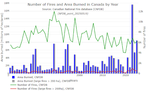
However, recent wildfire seasons have demonstrated a shift in both scale and impact. In 2023, the wildfire season became the largest in recorded Canadian history, and burned 15 million hectares of land (more than 6,000 fires). The season forced a mass evacuation of 185,000 people.
When driving through the Canadian Rockies today, you will see several kilometres of these burn scars. For example, in Jasper, you will see dark, branchless tree trunks standing like matchsticks against the mountainside. These forests require decades to recover.
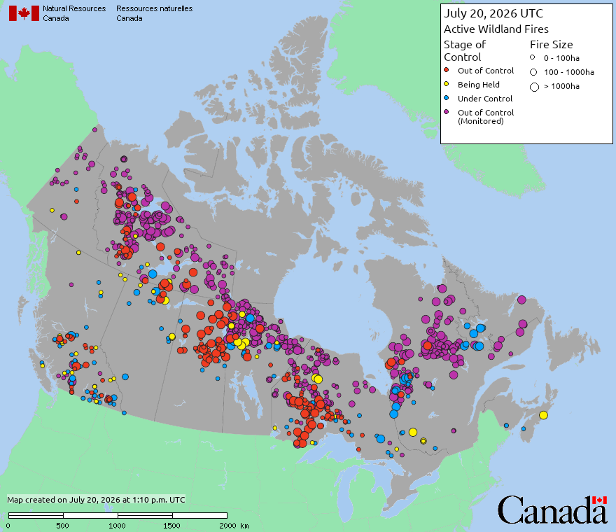
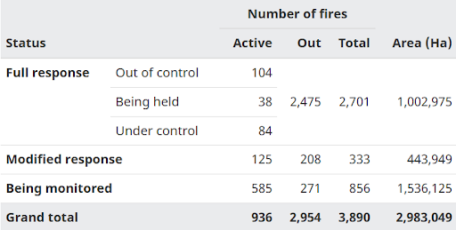
According to the latest national data, there are nearly 940 active wildfires burning across the nation. The numbers change daily. However, they highlight an important fact: wildfires are no longer an isolated issue affecting only remote forests. They impact major cities, critical infrastructure, businesses, and millions of Canadians.
In British Columbia, where fires are recurring, 13.79% of the province strongly agrees that “Global warming is a natural occurrence” (indexing at a massive 131 compared to Canada overall). These residents have had to culturally adapt to this crisis as a regular, natural lifecycle event. Ontario is, however, behind in this psychological shift (9.48% compared to 13.79% of BC residents). This explains why the orange sky over the GTA came as such a terrifying shock to a population adjusting to the reality of an extended wildfire season.
Why Wildfire Seasons Are Changing
Canada experiences an average of 7,000 fires per year, burning an average of 2.7 million hectares of land.
Although fewer wildfires are occurring, the total area burned has been increasing dramatically. Scientists attribute this to a combination of warm temperatures, earlier snowmelt, prolonged drought, and longer wildfire seasons. These conditions allow individual fires to grow much larger, burn longer, and become more difficult to contain.
As a result, wildfires are affecting more communities, producing more smoke, and burning more land than previous decades, even if the total number of wildfires has decreased.
Why Does Canada Experience So Many Wildfires?
Canada experiences some of the largest wildfire seasons in the world. Ranking third globally, Canada contains nearly 9% of the world’s forests, dominated by the Boreal Forest that extends from Yukon to Newfoundland and Labrador (5,000 kilometres). This forest is one of the largest and most ecologically significant forest ecosystems on Earth.
This massive forest consists of highly flammable coniferous trees and stretches unbroken across the continent, so a single spark can easily trigger fires that spread across vast stretches of forest.
Lightning remains the leading natural cause. Although it starts fewer fires than people do, it is responsible for most of the area burned each year. Many lightning strikes occur in remote regions, where a fire can burn for days before fire crews can respond.
Humans play a large role in wildfires too. For example, unattended campfires, improperly discarded cigarettes, railways, off-road vehicles, power lines, and agricultural burning can all ignite dry vegetation under the right conditions.
Most human-caused fires occur closer to communities, which allows firefighters to respond much faster. Nevertheless, they can still become dangerous when weather conditions are favourable.
Several environmental factors also influence wildfire behaviour:
- Extended drought causes forests and grasslands to ignite easily.
- High temperatures remove additional moisture from vegetation.
- Low humidity allows fires to spread at a rapid rate.
- Strong winds push the flames into new areas and carry burning embers far from the fire, creating new ignition points.
Together, these conditions can cause a small fire to become a nationwide emergency.
Understanding Canada’s Active Wildfires
When people hear that Canada has hundreds of active wildfires, they usually assume that every fire has been spreading uncontrollably. This is not the case. Fire management agencies have classified wildfires into several different categories.
- Under Control: Firefighters have successfully contained the fire, and they expect it to remain within its existing boundaries.
- Being held: The fire is not currently growing beyond its containment lines, but changing weather conditions can cause it to spread.
- Out of Control: The fire continues to spread and cannot be fully contained yet.
Not all wildfires pose the same level of risk, so the distinction is important. Some fires are relatively small and are monitored closely. Others burn through forests for weeks before weather conditions allow firefighters to contain them.
Unfortunately, large fires produce enormous amounts of smoke regardless of whether they threaten the nearby communities directly or indirectly.
The smoke will ultimately affect millions of people living thousands of kilometres away, even those in other countries.
Canada’s Wildfire Seasons by the Numbers
The scale of Canada’s wildfire season is difficult to understand without looking at numbers.
As of July 20, 2026 at 9am EDT:
- Number of affected provinces and territories: 10 jurisdictions reporting fires (British Columbia, Alberta, Saskatchewan, Manitoba, Ontario, Quebec, New Brunswick, Newfoundland & Labrador, Yukon, and the Northwest Territories).
- Communities under evacuation orders or alerts: 6 First Nation communities under mandatory evacuation orders, several more on high alert.
Currently, the most pressing emergency is unfolding in Northwestern Ontario, where dry conditions and severe lightning have caused dozens of fires to expand (including the Thunder Bay 36 fire, which has expanded to over 350,000 hectares).
Due to the extreme threat to human safety, mandatory evacuations have been ordered for the following:
- Armstrong
- Whitesand First Nation
- Namaygoosisagagun (Collins) First Nation (where fires have unfortunately already destroyed homes and local infrastructure)
- Lac des Mille Lacs First Nation
- Gakijiwanong Anishinaabe Nation (Lac La Croix)
- Gull Bay First Nation
Why Does Wildfire Smoke Travel So Far?
Large wildfires produce enormous amounts of smoke that rise thousands of metres into the atmosphere. Once there, upper-level winds transport fine smoke particles across the provinces, countries, or even continents.
As weather systems change, the smoke gradually moves back towards the ground.
Communities with nearby fires suddenly experience hazardous air quality as the smoke from distant fires settles over the region.
The primary health concern comes from PM2.5, the fine particulate matter that exists in wildfire smoke. These microscopic particles can remain suspended in the air for long periods of time, and can travel thousands of kilometres. Since these particles are so small, they can penetrate deep into our lungs and can easily enter our bloodstream. These small particles are what make wildfire smoke so dangerous.
That is exactly what happened in Toronto. The smoke travelled from northwestern Ontario and Quebec. This long-range transport reduced visibility dramatically, and caused air quality in Southern Ontario to plummet to some of the most hazardous levels recorded.
Additionally, this is why Canadian wildfire smoke reached New York City in 2023, and later on, Europe.
Wildfires may start in one location, but their impact rarely stays there.
Where are Wildfires Most Likely to Occur?
Although wildfires can start almost anywhere in the country, some regions have significantly more fire activity than others.
Most wildfire activity occurs throughout Canada’s boreal forest, stretching across much of the country from British Columbia to Newfoundland and Labrador. These areas contain dry vegetation, remote terrain, and frequent lightning strikes.
However, geography is only part of the story. Periods of persistent low precipitation, prolonged heat, and strong winds can quickly increase the risk of wildfires across entire provinces. A single strike of lightning can ignite dozens of small fires in one day, which stretches the area’s firefighting resources across hundreds of kilometres.
Because Canada covers such a large landmass, wildfires rarely only affect one province. While one region may experience heavy rainfall, another may be facing severe drought and extreme fire danger. As a result, wildfire has become a national issue rather than a regional one.
The Human Cost of Wildfire
When people think about the wildfires in Canada, they often think of remote areas being affected. However, the greatest impact is often felt by those forced to evacuate their homes.
Throughout recent wildfire seasons, thousands of Canadians have received evacuation orders with no warning. Thousands of families have had to pack essentials and flee their homes, having to wait weeks before learning whether or not their homes survived.
For many of our northern communities, evacuation is not as simple as driving to the next town. Remote communities often have very limited road access and rely on aircraft when fires threaten road closure. Coordinating these evacuations requires enormous amounts of cooperation between local governments, emergency responders, Indigenous leadership, provincial agencies, and sometimes the Canadian Armed Forces.
Historically, First Nations communities have faced some of the greatest challenges. Many of these communities are located in remote areas where the wildfire risk is much higher because of the surrounding forests. Limited transportation makes evacuation more difficult, and rebuilding after a fire takes far longer than it would for those living in larger urban centres.
This year, several First Nations communities across northern Ontario and Manitoba have once again been forced to evacuate as wildfires continue to intensify. Additionally, some of these communities have had to evacuate multiple times over the past couple of years.
Beyond the immediate danger, the repeated evacuations have created lasting social and emotional impacts. Evacuation often means saying goodbye to homes, pets, cultural sites, and the uncertainty of whether anything will remain when they return. Families may spend weeks away from their homes, children miss schools, healthcare becomes increasingly harder to access, and entire communities face uncertainty about when (or if) they will be able to return. As wildfires continue to intensify, these challenges become more and more common.
Wildfires Affect More Than Forests
The impacts of wildfire extend far beyond the flames; poor air quality affects millions of Canadians.
People with asthma, chronic obstructive pulmonary disease (COPD), heart problems, or other respiratory conditions often face a much larger health risk during prolonged smoke events.
Outdoor workers also experience many challenges. Construction crews, landscapers, utility workers, farmers, and delivery personnel often have their hours cut, or must follow additional health precautions when smoke reaches hazardous levels.
Tourism in these remote areas also takes a direct hit. Campgrounds close, hiking trails become inaccessible, and visitors cancel their trips when wildfires threaten popular destinations. National and provincial parks are often closed as well. As a result, local businesses that depend on seasonal tourism lose valuable revenue during their peak travel seasons.
Major events are affected as well. Sporting events, concerts, festivals, and other community celebrations increasingly require contingency plans for poor air quality. Schools often cancel outdoor activities, and municipalities often adjust recreational activities when the smoke reaches unhealthy levels.
Last but not least, wildfires strongly impact transportation. Reduced visibility causes delayed flights, highway closures, and rail disruptions which interrupt the movement of people and goods.
Wildfires are no longer just an environmental issue.
It is increasingly a public health issue, an economic issue, and a planning issue.
Bridging the Gap in Risk Perception
To understand the true rift in public perception, we have to look closely at the data. According to the latest psychographic database from Vividata, modeled at a micro-geographic level by Manifold Data Mining, the psychological divide between climate concern and climate indifference in Ontario is stark.
Recent data shows that one in five Ontario residents (19.95%) strongly agree that “it costs too much to be green all the time”, while 15.38% believe green initiatives are just a government money-maker. However, the smoke over the Toronto skyline demonstrates that inaction carries the true price. The economic toll isn’t found in green products; it’s found in:
- The 7.87% of Canadians who already feel there is too much emphasis on conservation are now facing disrupted transportation and commuting.
- Billions in supply chain disruptions, less tourism revenue, and cancelled outdoor work hours for construction and agricultural crews.
- Rising insurance costs and long-term property devaluation in high-risk zones.
- 23.28% of Ontario residents strongly believe that “climate change is the biggest threat to civilization” (the national average is 23.79%). For this population, the orange sky on Wednesday was a horrifying confirmation of their fears.
- Conversely, 9.20% of Ontario residents strongly agree with the statement, “I don’t care what my carbon footprint is”.
- Similarly, 11.8% of locals believe “there is too much concern with the environment”, even as extreme wildfires continue to trigger toxic air warnings all across the nation.
Why Data Matters During Wildfire Seasons
Responding to wildfires requires more than maps showing where the flames are. Decision-makers also need to understand who lives nearby, which populations may be vulnerable, and where resources will be most beneficial.
Older adults, young children, individuals with respiratory conditions, and communities with limited healthcare often face the greatest risk during prolonged smoke events.
Understanding where these populations live allows governments, healthcare providers, insurers, municipalities, and businesses to make more informed decisions before or during wildfire season.
A wildfire map shows where the fire is.
Population data shows who gets affected.
Together, these insights help organizations allocate resources, identify vulnerable communities, improve emergency planning, and better understand the broader impacts of environmental events.
As wildfires continue to influence more and more Canadian communities, the value of localized data will only continue to grow.
Looking Ahead
Within days, our skies will clear, the air quality will improve, and we’ll all go back to our normal routines without having to, once again, rely on N95 masks. Yet, the broader story won’t end there.
Over the past several years, wildfires have repeatedly affected hundreds of communities across Canada and beyond. Smoke has travelled across Canada, and even into other countries where it has affected millions of people living far from the flames.
These events are no longer rare headlines. They are recurring events that remind us how interconnected our environment, infrastructure, economy, and communities really are.
Wildfires have always been part of Canada’s natural landscape. The difference is now in the scale of their impact.
Understanding the impacts of these wildfires requires more than monitoring the flames themselves. It requires understanding the people, communities, and places that lie in their paths.
As Canadians continue to adapt to longer and more complex wildfire seasons, reliable data will continue to play an important role in helping governments, businesses, and organizations make informed decisions.