
What is Postal Code Geography?
Postal code geography is created and managed by Canada Post Corporation (CPC). A 6-digit postal code can be
- a block face (one side of a city street between consecutive intersections)
- a community mailbox or super mailbox
- an apartment building
- a business building
- a large firm or organization that does considerable business with CPC
- a federal government department, agency or branch
- a mail delivery route (rural, suburban or mobile)
- general delivery at a specific post office
- one or more post office boxes.
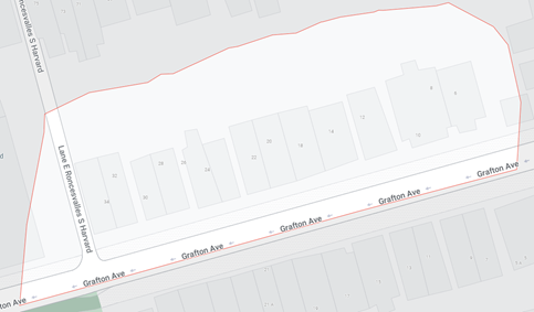
For example, the postal code “M6R 1C4” represents 14 addresses ranging from 6 to 34 on the street “GRAFTON AVE” in TORONTO, ONTARIO.
Around 500 to 1,000 new postal codes are introduced each month, e.g., new buildings or residential areas. At the same, some postal codes are “retired” after which they are no longer used. Postal codes are primarily used for sorting and delivering mailings: letters, parcels, and other mail. They are not designed for collecting and publishing population statistics.
What is Census Geography?
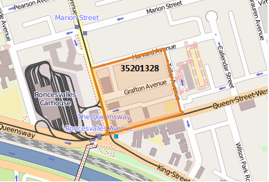
Census geography is created and maintained by Statistics Canada. They are designed and used for collecting, analyzing, and publishing statistics on Canada’s population, resources, economy, society, and culture. Census geography is composed of multiple layers (e.g. CMA, CSD, CD, DA, etc.). Census geography covers a wide range of geographic areas—from provinces and territories down to blocks. Dissemination Areas (DA) are the most granular areas where mostly complete Census data have been published by Statistics Canada. They are not widely known. E.g. who knows which Dissemination Area or Census Tract they live in? The following map illustrates a Dissemination Area “35201328” in Parkdale/Liberty Village, Toronto, Ontario.
Postal Codes and Dissemination Areas
Linking postal codes to the Statistics Canada geographic areas is essential for Manifold to transfer data from Census geography to postal geography, so that clients can combine their customer or area data with Manifold’s data products to gain insights into their customers and markets, perform comprehensive analysis, prospect scoring, segmentation, and derive predictive models or machine learning models to help their business. Clients may also use the linkage to do site selection, territory mapping, trade area analysis, and understand market potential or do strategic planning.
What do Dissemination Areas (DAs) and Postal Codes Look Like in Urban Areas?
In urban areas, 6-digit postal codes are generally much smaller than Dissemination Areas and they can be completely inside the associated DAs. However, many postal codes straddle multiple DAs. For example, in the following map the colour-coded areas outlined with thin grey lines represent 6-digit postal codes with different household income ranges.
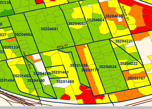
The navy blue lines are census boundaries of Dissemination Areas marked with numbers. DAs “35204221”, “35204222”, “35204189” and “35204190” are examples where postal codes straddle across two different DAs.
What do Dissemination Areas (DAs) and Postal Codes Look Like in Rural Areas?
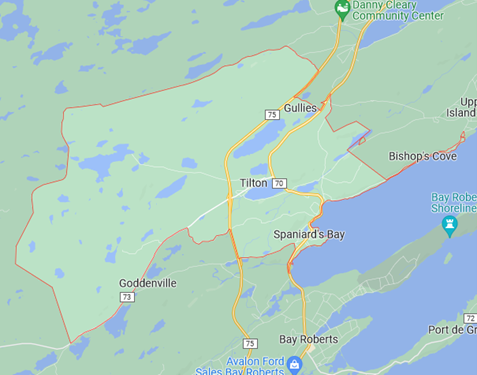
Rural areas are often in a reverse situation, where a 6-digit postal code can cover multiple communities and multiple DAs completely. For example, the postal code “A0A3X0” in Newfoundland contains the complete communities: Tilton, Gullies, Bishop’s Cove, Goddenville and Spaniard’s Bay, and the associated DAs: “10010526”, “10010762”, “10010766” and “10010767”. See the map below.
What are Different Ways to Link Postal Codes and DAs/Split Postal Codes and DAs?
In order to reflect population statistics at the postal code level accurately, we need to precisely split postal codes which straddle multiple DAs, and vice versa, DAs which straddle multiple postal codes. Some companies use geographic area (aka land and water area) to calculate the overlap of postal codes and DAs, and by extension to calculate population statistics.
How Do We Link or Split Postal Codes and DAs?
At Manifold, we calculate the number of households in the overlapping areas and use them to derive weights to split postal codes and DAs. We believe the household approach is more appropriate than other approaches to model population statistics.
If you have any questions, please feel free to fill out the contact us form at Contact Us or reach out to your Account Manager.